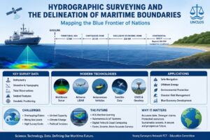
Automating Spatial Workflows in ArcGIS Pro
📌 What is ArcGIS Pro Automation? ArcGIS Pro automation involves using built-in tools such as ModelBuilder, Geoprocessing tools, and scripting […]
Automating Spatial Workflows in ArcGIS Pro Read Post »
📌 What is ArcGIS Pro Automation? ArcGIS Pro automation involves using built-in tools such as ModelBuilder, Geoprocessing tools, and scripting […]
Automating Spatial Workflows in ArcGIS Pro Read Post »
ArcGIS Field Maps is a map-centric mobile application that allows Surveyors to take their maps everywhere they go. It brings
ArcGIS Field Maps for Field Data Verification and Editing. Read Post »
Surveying practice has continued to evolve with the integration of geospatial technologies. ArcGIS Survey123, an Esri data collection solution, provides
ARCGIS SURVEY123 AS A MODERN DATA COLLECTION TOOL FOR SURVEYORS Read Post »
Implementing advanced geospatial technologies in construction projects involves a thorough cost-benefit analysis to determine their financial viability and potential advantages.
Surveying accuracy is greatly impacted by environmental conditions, particularly on difficult construction sites. These elements may impact data gathering, increase
ENVIRONMENTAL IMPACT ON SURVEYING ACCURACY IN COMPLEX CONSTRUCTION SITES Read Post »
Integrating geospatial data with other construction management systems involves combining geographically referenced information like site topography, utility lines, and property
INTEGRATION OF GEOSPATIAL DATA WITH OTHER CONSTRUCTION MANAGEMENT SYSTEMS Read Post »
Geospatial analysis plays a crucial role in optimizing construction sites by leveraging spatial data, geographic information systems (GIS), and remote
GEOSPATIAL ANALYSIS FOR CONSTRUCTION SITE OPTIMIZATION Read Post »
21 Century represents a new era of human history, marked by unprecedented technological advancements, global connectivity and complex challenges. Surveying
21st CENTURY SURVEYING CURRICULUM IN TERTIARY INSTITUTION Read Post »
▶️ Who is a woman Professional? A woman Professional is an individual who identifies as a female that possesses specialized
ADVANTAGES OF WOMEN IN MANAGERIAL POSITION IN SURVEYING COMMUNITY Read Post »
What is National Development? National development refers to the process of economic, social, and political growth and improvement of a
ACTIVE PARTICIPATION OF REGISTERED SURVEYORS IN PARTY POLITICS FOR NATIONAL DEVELOPMENT Read Post »
What does it mean for Surveyors to have programming Skills? Programming skills are essential for creating Software Apps Websites Digital
THE NEED FOR SURVEYORS TO HAVE PROGRAMMING SKILLS Read Post »
▶️ Who is a woman Professional? A woman Professional is an individual who identifies as a female that possesses specialized
ADVANTAGES OF WOMEN IN MANAGERIAL POSITION IN SURVEYING COMMUNITY Read Post »
The future of Surveying in Nigeria holds immense potential, driven by the increasing demand for accurate geospatial data, technological advancements,
THE FUTURE OF SURVEYING IN NIGERIA Read Post »
Let’s look at some solutions targeting today’s topic: 1. Technological Advancements and Adoption Facilitate Access to Modern Equipment: Professional
1.0 Introduction Spatial hydrography, a subset of hydrography, involves studying and mapping water bodies, focusing on their spatial relationships and
EXPLORING SPATIAL HYDROGRAPHY: UNLOCKING THE POWER OF WATER RESOURCE MANAGEMENT Read Post »
Remote Sensing technology is revolutionizing how we monitor and manage our environment, providing critical data for addressing some of the
How Remote Sensing is Transforming Environmental Monitoring Read Post »
Hello, Surveyors! Last week, we discussed the essential Safety Protocols for Surveying. This week, we’re exploring real-life scenarios from the
Real-Life Safety Scenarios in Surveying Read Post »
Today our focus will be on Augmented Boundaries. Land-surveying involves knowing the boundaries of subdivided land and Augmented Reality can
Augmented Boundaries Read Post »
Hello, Surveyors! Today, we’re exploring a vital aspect of our profession: Safety Protocols in Surveying. Safety is not just about
Safety Protocols in Surveying Read Post »
In the rapidly evolving world of land surveying, new technologies are transforming the way professionals capture and analyze data. This
New Innovations of Land Surveying Technologies Read Post »
Today our focus will be on Point Cloud Drafting. Point cloud drafting is not a recent technology but with the
Innovative Land Surveying Technologies Read Post »
Geospatial Data refers to information about the physical location and characteristics of natural and man-made features including boundaries on, above,
Ethical Considerations in Geospatial Data Collection and Use Read Post »
Geospatial analysis, which involves the collection, visualization, and interpretation of geographic data, has become a pivotal tool in various fields,
Geospatial Analysis for Public Health: A Critical Tool for Modern Medicine Read Post »
COVID-19 made staying indoors unconventional, It also opened doors to IPS. The need for accurate indoor navigation and location-based services
Navigating the Indoors: The Evolution and Impact of Indoor Positioning Systems Read Post »
Marine Geomatics is a multidisciplinary field that applies geospatial technologies to study and manage marine environments. From mapping the ocean
Navigating the Depths: Exploring Marine Geomatics Read Post »
Climate Change Impact Assessment Using Geospatial Technology Climate change is one of our most pressing global challenges, affecting ecosystems, weather
Climate Change Impact Assessment Using Geospatial Technology Read Post »
Scholarships for prospective MSc and PhD students in Geoinformation and Surveying are crucial as they alleviate financial barriers, allowing students
Geoinformatics and Surveying Scholarship Opportunities. Read Post »
Some specifications need strict adherence while planning and executing a survey to obtain inputs of adequate precision that satisfy the
Calibration and Verification Tests of Survey Equipment. Read Post »
Professional certifications for surveyors and permits for survey practice are paramount in ensuring credibility, safety, accuracy, and legal compliance in
Professional Certifications and Permits for Surveying Practice Read Post »
Emerging technologies are revolutionizing the field of Surveying, enhancing accuracy, efficiency, and the overall scope of work Surveyors can perform.
Emerging Technologies in Surveying Read Post »
Drone Mapping Drone mapping is a remote sensing technology for creating 2D and 3D maps of an area using data
Drone Mapping and Security Read Post »
A drainage network refers to a system of interconnected channels, pipes, or natural watercourses designed to manage the flow of
Aspects of Improvements of Drainage Networks in Nigeria Read Post »
DEM and DSM Digital Elevation Model (DEM) and Digital Surface Model (DSM) are both types of digital representations of the
Analyzing The Differences Between DEM and DSM Read Post »
Self-development in the Surveying profession is crucial for staying competitive and effective in a field that is constantly evolving with
Self-Development in the Surveying Profession Read Post »
we talked about the role data management plays in surveying we also discussed key aspects, today we will discuss the
ADVANTAGES AND DISADVANTAGES OF DATA MANAGEMENT IN SURVEYING Read Post »
Data Management in surveying is a crucial aspect of the surveying process. It involves systematic organization, storage, processing, analysis, and
DATA MANAGEMENT IN SURVEYING Read Post »
Urban sprawl refers to the uncontrolled, unplanned, and often expansive growth of urban areas into surrounding rural or undeveloped land.
Factors and Roles of Surveyors in the Urban Sprawl of Cities in Nigeria. Read Post »
Georeferencing is the method of assigning real-world coordinates to each pixel of the raster. Usually, these coordinates are obtained by
Importance and Methods of Georeferencing Read Post »
Surveying isn’t just about measuring land; it’s a fundamental tool in various research disciplines, enabling precise data collection, analysis, and
Bridging the Gap: Surveying Applications in Research Read Post »
What is Blockchain? Blockchain is a method of recording information that makes it impossible or difficult for the system
Blockchain in Land Administration Read Post »
LiDAR (Light Detection and Ranging) technology has revolutionized the field of Surveying, providing precise and efficient methods for mapping and
Applications of LiDAR Technology in Surveying Read Post »
SDI is a framework of technologies, policies, and standards that enables the efficient discovery, access, sharing, and use of geospatial
SPATIAL DATA INFRASTRUCTURE (SDI) FOR SMART CITIES Read Post »
This is our opportunity. Together, we are the future of Surveying.
Welcome To Young Surveyors Network FCT Read Post »